Classificaiton_Naive Bayes This post demensatrate some basic process of Land Use and Land Cover classification using Naive Bayes in Python. Introduction In this chapter we will classify the Sentinel-2 image we’ve been working 2023-01-07 Machine Learning > LULC #LULC #Python #Naive Bayes #R #Coding #Classification
Random Forest - Getting Started Getting started with Random Forest! What is Random Forest Random forest classifier is an ensemble tree-based learning algorithm. The random forest classifier is a set of decision trees from a randoml 2023-01-07 Machine Learning > LULC #LULC #Python #R #Coding #Random Forest #Classificcation
Installation: Python, miniconda and Jupyter Python Miniconda installation and confirguration Jupyter installation and configuration 由于多个环境中只需要安装一个 Jupyter ,这里将 Jupyter 单独安装在一个环境中,对其他环境进行隔离。若安装在其他环境中,则运行 Jupyter 需要进入安装时的环境1。 123conda create - 2023-01-04 Python #Python #Insatllation #Miniconda #Jupyter
Supervised classification of LULC using Sentinel-2A and Random Forest This post is about some notes and steps while doing research: LULC supervised classification using Sentinal-2A dataset,and Random Forest machine learning method. Pre-process Before starting process o 2023-01-02 LULC #SNAP #LULC #Random Forest #Sentinel-2
Presentation: Introduction to GIS 地理信息系统概论试讲 - 提纲 PG1 现实世界 - GIS 现实世界中我们每天所见的山、树、道路、河流等等如何映射到GIS中呢,就是我们今天要讨论的问题。 为了能够利用地理信息系统工具解决现实世界中的问题,首先必需将复杂的地理事物和现象简化和抽象到计算机中进行表示,处理和分析。这就需要对现实世界进行抽象建模,其结果就是空间数据模型。 地理空间 所谓的地理空间,我 2022-12-20 #GIS
Data preparation of land subsidence susceptibility mapping analysis in Xuzhou Introduction Data Preparing DEM An advanced space borne therman emission and reflection radiometer (ASTER) digital elevation model (DEM) was obtained (1 arc second or approximately 30 meter resolut 2022-11-08 Xuzhou #Land Subsidence #Machine Learning #Land Subsidence Susceptibility Mapping
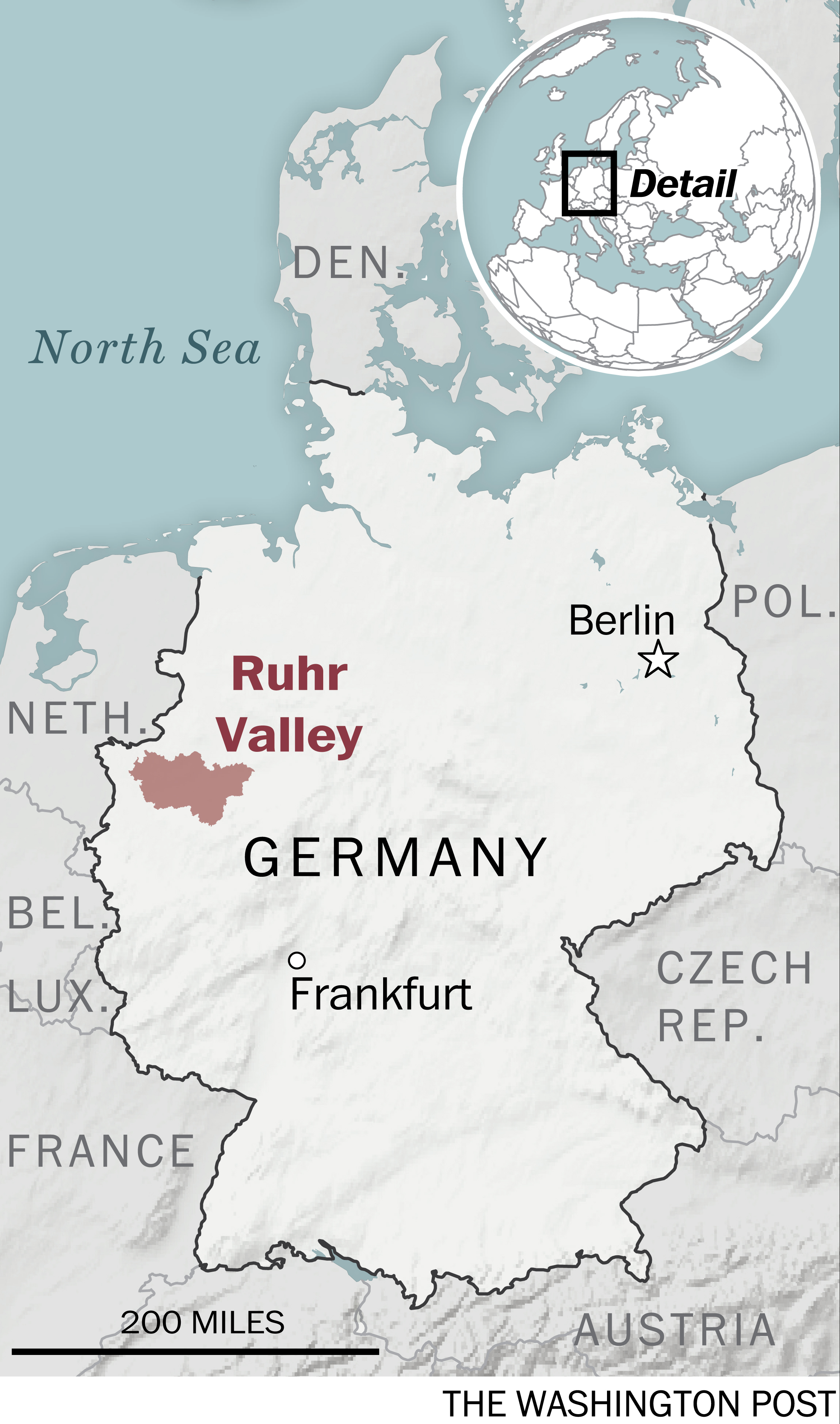
StaMPS Process of Ruhr Intro In order to compare the influence of coal mining activity 1nd it’s further impact in city, we conduct a series research both include Xuzhou city and Ruhr valley in Germany, which is known by co 2022-09-18 SAR #InSAR #Land Subsidence #PS-InSAR #LiDO3 #Sentinel1-A #StaMPS-InSAR #snap2stamps #Ruhr
StaMPS Results Analysis of Xuzhou in GIS Intro After export csv file in MATLAB, further analysis should be done in GIS program, like ArcGIS or QGIS. This post is about works after ‘Post StaMPS Analysis in Xuzhou’. ArcGIS Pro ArcGIS pro is 2022-09-16 GIS #Land Subsidence #QGIS #Xuzhou #ArcGIS Pro #StaMPS-InSAR #Sentinel_1A
Getting started with LaTex, VS Code and Overleaf Intro Start learning to write thesis, papers, reposts, slides or everything you want using LaTex in Visual Studio Code linked with github and overleaf. LaTex LaTeX is a high-quality typesetting sys 2022-09-08 Tools #LaTex #Visual Studio Code
Land Cover Classification using Sentinel2 and Deep Learning Intro This post is about getting to know LULC classificaiton using Sentinel 2 based on deep learing. 2022-06-30 Deep Learning #Deep Learning #LULC #Land Cover Classification #Sentinel 2